"GNSS systems provide near-global coverage and are used heavily in services for military operations, maritime shipping, aviation, mapping, smartphone services, and more."

Global Navigation Satellite Systems (GNSS) have become an integral part of our daily lives, powering a wide range of geolocation applications, from military operations to smartphone navigation and everything in between. In fact, almost no human or economic activity today functions without the use of GNSS systems, so it’s safe to say that understanding these systems' complexities and vulnerabilities is paramount.
To understand how and why Global Navigation Satellite Systems are essential, we must first understand what GNSS is, how these systems are interconnected with our daily lives, and what threats GNSS jamming and spoofing can impose on people, governments, and militaries.
What Is GNSS?
GNSS, or Global Navigation Satellite Systems, are networks or constellations of satellites in space that are used to send position and timing data to earth-based GNSS receivers for geolocation purposes.
GNSS systems provide near-global coverage and are used heavily in services for military operations, maritime shipping, aviation, mapping, smartphone services, and more. Once a satellite signal reaches an earth-based GNSS receiver, the receiver can determine its precise location using the data, measuring the distance between four or more satellites in a network.
In the past, GNSS receivers would calculate their location from four satellites within the same GNSS constellation. Today, however, GNSS receivers can determine their location with satellites in numerous GNSS-compatible networks - ultimately increasing the accuracy and integrity of geolocation at some of the furthest corners of the planet.
Different Types of Global Navigation Satellite Systems (GNSS)
As of 2024, there are four Global Navigation Satellite Systems in operation.
Global Positioning System (GPS) - United States of America
Global Navigation Satellite System (GLONASS) - Russia
BeiDou Navigation Satellite System - China
Galileo - European Union
The Global Positioning System (GPS), operated by the United States, is the oldest and most widely used GNSS system globally. GPS was developed by the US Department of Defense in the 1970s and was built primarily for US military applications - initiating its operations in 1978. Today, GPS has evolved to encompass applications that involve nearly everything we do in our daily lives and is used for both civilian and military applications.
GNSS vs. GPS
As described in the sections above, Global Navigation Satellite Systems (GNSS) are networks of satellites that provide location and timing data for numerous earth, atmospheric, and space-based applications. While GNSS is a broad and encompassing term, GPS (Global Positioning Service) is a single satellite positioning service operated by the United States of America.
The primary difference between GPS and GNSS is that GNSS receivers are compatible with GPS, but not all GPS receivers are compatible with GNSS. Since there are more operational GNSS satellites than GPS-specific satellites, GNSS receivers often provide more accuracy and reliability.
4 Key Criteria for GNSS Performance
There are four key criteria to evaluate how a GNSS or GPS system is performing or will perform in the future.
1. Accuracy
Accuracy describes the difference between a receiver's measured and real position (speed or time).
2. Integrity
The system's ability to provide a threshold of confidence.
3. Continuity
The system's ability to operate or function without interruption.
4. Availability
The percentage of time a signal fulfills the above criteria (accuracy, integrity, and continuity).
Additional Performance Evaluation Info - Timing
Having precise timing data is pivotal to all GNSS applications. Everything from communication systems to electrical grids and financial networks use timing data to synchronize processes and operate at the highest level of efficiency, and GNSS satellites are the key to delivering precise data.
Every GNSS satellite is equipped with multiple atomic clocks, allowing pinpoint accuracy within the timing signal transmissions. Once a GNSS receiver receives signals from a satellite, it can be synchronized to the satellite’s atomic clocks, allowing users to time processes down to the billionth of a second.

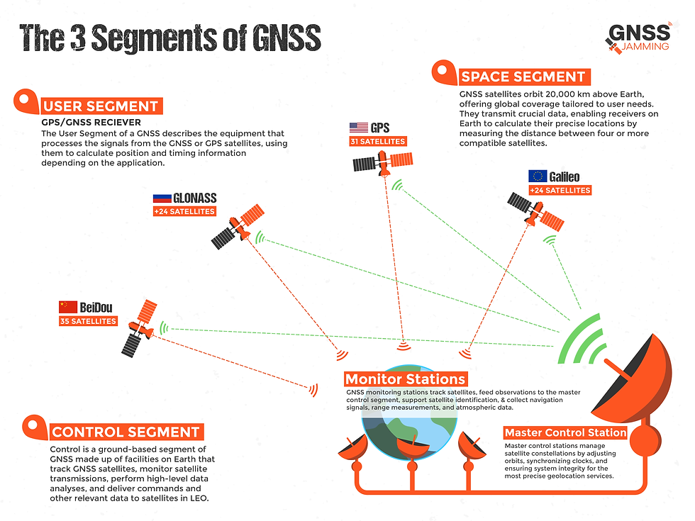
3 Segments of Global Navigation Satellite Systems (GNSS)
There are three segments of any GNSS system.
Space (Satellite Constellations)
Control (Master Control Stations)
Users (GNSS Users)
Space Segment
The space segment describes networks or constellations of satellites in space, which operate in Low Earth Orbit around 20,000 km above Earth. The satellites in the space segment are tasked with orbits that provide optimal coverage for the desired end user, which can vary significantly based on the user or application.
GNSS satellites transmit data describing their current and predicted location in space, with timing data being the most impactful for accurate geolocation.
Once the data is transferred from the satellites to the GNSS receivers, the receivers calculate their position on Earth by measuring the distance between four or more compatible satellites (often within the same network, but less often as more satellites become network-compatible).
Control Segment
Control is a ground-based segment of GNSS systems and is made up of facilities on Earth that track GNSS satellites, monitor satellite transmissions, perform high-level data analyses, and deliver commands and other relevant data to satellites in LEO.
For example, the Global Positioning System (GPS), operated by the United States, is made up of the following.
Master Control Station
Alternate Master Control Station
11 Command and Control Antennas
16 Monitoring Sites
The above GPS facilities are shown on the following map, updated in May 2017.

Source: GPS.gov
Master Control Station
The master control stations send commands to adjust the orbital parameters of satellites, adjust onboard satellite clocks when needed to maintain or improve accuracy, compute precise satellite locations with station data, monitor satellite broadcasts to ensure system integrity, perform maintenance and anomaly resolution tasks, and reposition satellites within a constellation to provide optimal data delivery.
In a nutshell, master control stations are the center of the GNSS network and provide the ability to manage satellite constellations for the most accurate geolocation.
Command and Control Antennas
The command and control antennas, also called ground antennas, are able to collect telemetry data, communicate with satellites in the S-band for anomaly resolution and orbit support, and send commands, navigation data, and processor program loads to orbiting satellites.
As another example, GPS consists of 4 ground antennas, with seven US Air Force Satellite Control Network tracking stations.
Monitoring Sites
GNSS monitoring sites, or GNSS monitoring stations, are able to carry out many of the necessary monitoring tasks within a global navigation network. GNSS and GPS monitoring stations can track satellites as they pass overhead in space, feed observations to the master control segment, use GPS receivers to support satellite identification, & collect navigation signals, range measurements, and atmospheric data.
GPS provides global coverage with 16 monitoring sites: six from the US Air Force and ten from the National Geospatial-Intelligence Agency (NGA).
Once satellites are monitored from these stations, the data is passed along to the master control station for further analysis.
User Segment
The User Segment of a GNSS describes the equipment that processes the signals from the GNSS or GPS satellites, using them to calculate position and timing information depending on the application.
Equipment can be anything from smartphones to portable GNSS or GPS receivers.
GNSS Applications
There are seemingly countless applications for GNSS and GPS systems today. However, the primary and arguably most important applications are listed below.
Military Uses
Maritime Industry
Aviation
Mapping and Surveying
Military
GPS, the most prominent type of GNSS, was first developed for military applications by the US Department of Defense in the 1970s.
GPS provides two primary services: the Precise Positioning Service and the Standard Positioning Service.
The Precise Positioning Service is one of the most advanced military services in the world, and it is only available to the United States Military and its allies. The service is highly encrypted and has anti-jamming features that help keep it secure, and it can even detect nuclear detonations across the globe.
The most common applications of GNSS and GPS for the US military are:
Navigation (Land, Air, & Sea)
Target Acquisition
Reconnaissance
Weapons Guidance
Maritime
The maritime industry needs to address issues concerning safety, efficiency, and optimization with tact, and GNSS systems can help support nearly every aspect of operation in the maritime sector. GNSS helps with everything from navigation to fishing, exploration, and commerce, so the implications of faulty GNSS could range from physical harm to severe economic loss.
Among the most common GNSS applications in the maritime sector is navigation, and it supports Automatic Identification Systems (AIS) and Vessel Tracking Systems (VTS) for collision avoidance and traffic control.
While navigation is a big one, other applications for GNSS exist within the maritime sector.
Sea Level Observations
Dredging Operations
Locating Wrecks
Pipeline Construction
Search and Rescue
Dynamic Positioning
Oil Rig Positioning
Satellite Launch Platform Maintenance
Aviation
Satellite navigation is paramount in the aviation industry, and GNSS has helped further progress with additional positioning services for different flight phases in both commercial and leisure flights.
GNSS is used to plan aircraft routes, time landings, and distance planes, so it’s clear that GNSS is a key element of safety and efficiency in aviation.
Other applications for GNSS in aviation include:
Altitude Determination
En-route Flight and Area Navigation
Performance-Based Operations
Mapping & Surveying
Mapping and surveying often need to have extreme precision and accuracy for geolocation to execute processes sufficiently. GNSS systems power our daily lives through mapping applications and support navigation for nearly every type of vehicle, aircraft, or device, ensuring public health and safety and guarding against extreme economic loss.
More applications for GNSS in mapping and surveying include:
Agriculture and Irrigation
Construction and Infrastructure
Environment and Climate Research
Academic Research
Fitness Trackers and Smart Devices
Drones and UAVs
Geotagging Electronics
Comentarios